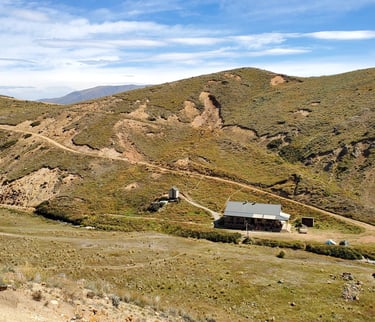
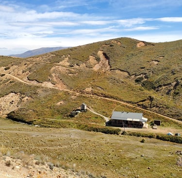
Woolshed Hut on the Mt Somers Track
Just over an hour's drive from Christchurch, this is a great day hike, popular with families and kids. Walk it in or out or do it in a loop. Choice is only one of the cool features of this awesome trail.
Mike Smith
5/10/20257 min read
Getting There
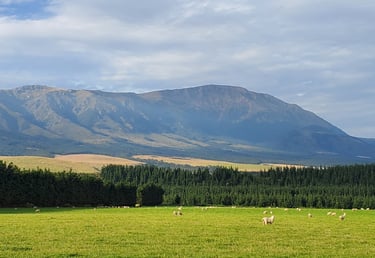
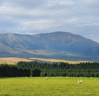
I love the drive out to this track! From Christchurch, head west out of town via Yaldhurst and West Melton. Instead of following State Highway 73 to Kirwee, Arthur’s Past (Lord of the Rings filming hot spot!) and the West Coast, you veer through the tiny rural sleepy hollows of Hororata and Windwhistle. The roads that this takes you on are some of the longest straights I’ve encountered. They thrust through stunning fields of various grains and deep green paddocks spotted with either sheep or cows. All the while, with the stunning Cantabrian foothills of the Southern Alps rearing up in the distance. I fantasise about what it’d be like to roar down these roads in my dream car, the Aston Martin DB9. My old Subaru Legacy carries me in reality. Roaring instead is the album Ivy and the Big Apples by Spiderbait, my favourite band when I was a teenager. Even if they are Aussies. It’s an eclectic mix of drop-tuned, driving, heavy rock tracks, punk rock blisters, and pop rock ditties. Once you hit the township of Mt Somers, turn right along Ashburton Gorge Road. Continue up about 10km and turn right onto Jig Road, following it to the carpark.
The Walk
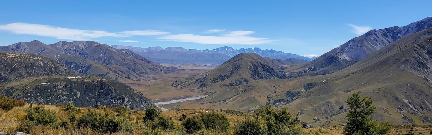
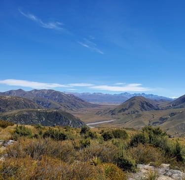
Mt Somers Track
The carpark is fairly full when I arrive at Woolshed Creek. A large group of kids and their parents mill around. I shoot to the toilet and add a couple of things from the passenger seat to my pack. I’m vaguely aware of the threat this rabble presents, but it is not until I’m about to leave and see they’re on their way too that I hurry my ass up to get ahead of them. It doesn’t help that I'm making a video of the walk for the first time and have to catch a bit of footage before setting off.
Thankfully, just as I am setting off, they are stalled by one of the many things kids stall you for and I make my way into the beech forest unimpeded. This is the track closest to the entrance of the carpark - the Mt Somers Track up through to Blackburn Mine and then on to the Woolshed Creek Hut. The track undulates through the forest next to the Woolshed Creek for a short time before heading away and further uphill. To your right is the western face of Mt Somers and on your left, hillsides that hide the wide open spaces behind them.
Within a short time the landscape becomes more tussock-filled, but still with the odd small stand of beech forest to pass through. After about an hour you will come across the “broken seams and broken dreams” of the long-retired Blackburn Coal Mine. You can find out more about its history here. When I arrived at the mine shaft entrance, sitting in front of it, was the family of a girl I teach. We had a chat about some of the challenges of education in New Zealand today and then I continued on my way… completely forgetting to have a good geez (= have a look) in the mine shaft which operates as a bit of an open air museum nowadays.
I had Bluetooth headphones with me and consider putting some music in to listen too, but… when I’m outdoors like this I kinda like to do away with the weight of daily life – phone, wallet, keys – as much as possible. Walking with a smartphone gimbal in my right hand was tending to rob me of a large part of that serenity though. The ‘editing these videos together and seeing if they can find an audience’ part of me was in conflict with the ‘connect with the calm of the outdoors’ side of me.
Rapid rises through tussocks onto small plateaus soon bring incredible views out to the west into the valleys around the Ashburton River. Somewhere around this point I meet a young boy and girl hiking seemingly alone. But ah, they’re not. There is their father and younger sister, roughly 300 metres away over on the 4WD track waving to them. The older girl, perhaps 11, is wearing a personal locator beacon. The younger boy is about 8. They tell me they go out and do this thing as a family quite a lot. The 4WD track is an awesome option for younger (or reluctant) children. I’m hoping I can bring my eight-year-old out sometime soon to give it a go. She falls into the reluctant category, unfortunately! About 20 minutes into the track, it appears there is a short, sharp zigzag up the hill and then from there you can fairly well meander along a ridgeline to the hut, avoiding a lot of the more strenuous up-and-down of the track.
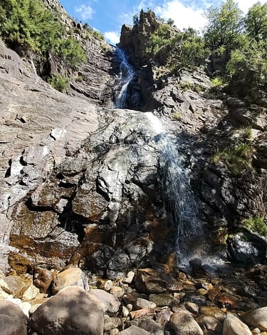
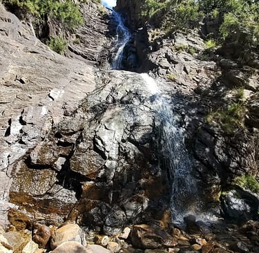
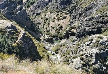
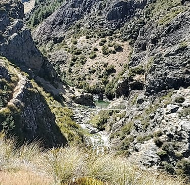
There is one final ascent before Woolshed Hut comes into view. From here you can see the swingbridge over a stream on the other side of Woolshed Creek. There is also a fairly spectacular waterfall. A jagged path leads you down the other side into the valley the hut sits in.
The hut has bunk beds for 26 inside. Bookings are required for these throughout the year. There is ample tenting space outside. Find out more about booking and the facilities available at the hut on the DOC website here.
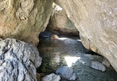
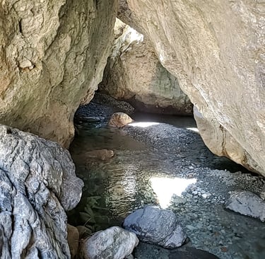
After a quick lunch, I crossed Woolshed Creek and headed up the slope and over the hill to the water caves. Whether these are ‘caves’ or more so some well-placed boulders is up for debate, but they certainly make for a pretty cool location to clamber around and explore. It wasn’t here that I wanted to take my swim for the day though. I wanted to try out the fabled Emerald Pool, so I wandered back the way I came, down the slope across from the hut again and on towards the swing bridge that marks the start of the Bus Stop Track. Rather than crossing the swing bridge though, I kept to the left and dropped down to the big rock that looms over the pool. Sneaking behind it, I found a little privacy from the family swimming there to change into my togs (= swimming trunks).
I contemplated a leap from the rock into the pool, shocking the woman already swimming when she realised I was being serious. Good judgment got the better of me though and I decided I better test the depth first. Not a place where you’d want a leg injury with a three hour walk out to the car park ahead of me. The water was bloody freezing so just a couple of full submersions were enough to cool me down and ready me for the trek back out.
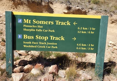
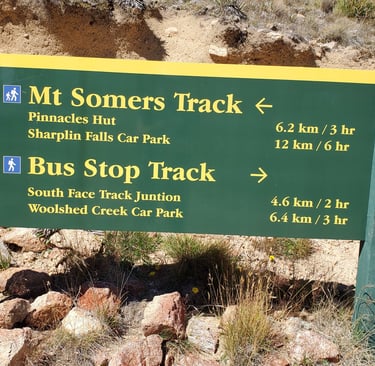
Bus Stop and South Face Tracks
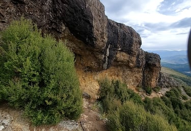
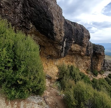
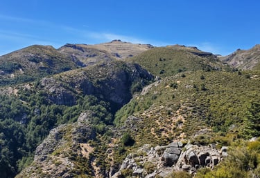
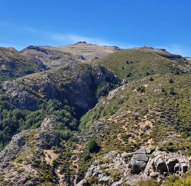
Crossing the swing bridge was great fun, as most swing bridges are. From here, the track ascends steadily on the western slope of Mt Somers. Mostly you are out in subalpine scrub with some amazing views back towards Woolshed Creek Hut and the valleys of the Ashburton River. At points it does flatten out a bit and enter into some lovely beech forest. A short signposted side trail takes you to a stunning two-tier waterfall, towering some 50+ metres skyward. Continued ascent takes you to the day’s highest point, just over 1100m, and to this trail’s namesake, the bus stop. The rock here has a spectacular orange tone to it and contrasted with the darker rock and soil around it is quick striking. The bivvy here could make a really cool place to camp overnight. The sunsets facing west would be absolutely spectacular I imagine!
From here, you descend to the tussock-filled slopes, some of it marshy. Thankfully some boardwalks have been built across these sections to protect the tussock (but also our feet!). There are some really cool rocky outcrops in this area. Once you get to the junction with the South Face Track, turn right towards the car park where you started from. Turning left is a long trail along the (as the name not even implies but straight out states) south face of Mt Somers, including the summit track which I’ve heard is a damn slog… one I might head back for one day.
It was at this point that my phone ran out of battery and I learned the lesson every vlogger must learn. Bring a power bank. If you’ve watched the video, you already know… In a big way though, I breathed a sigh of relief.
The remainder of the tramp is roughly 45 minutes to an hour zig zagging downhill. You will be able to see the carpark most of the way. There are some quite spectacular ridgelines and drop offs along this section to enjoy.
I took these pictures as I listened to the remainder of Ivy and the Big Apples on my way back home. If you’re in or from Christchurch and you’ve got a day and you want to get out in nature, this hike has heaps to offer – a cool drive out of town, mixture of beech and tussock, an alternative easier track for families, spectacular valley views, awesome water caves, refreshing emerald pools, a waterfall, and a bus stop.
You decide whether to bring your headphones or not.