Wye Creek Track - Trail Guide
Looking to get into nature in the Queenstown area? Forget hiking Queenstown Hill. Get a bit further out of town on the Wye Creek Track with this trail guide to what is surely one of the best half-day trails in the area.
Mike Smith
5/8/202410 min read
Getting there
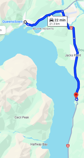
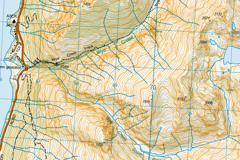
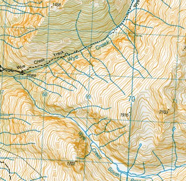
The start of the Wye Creek Track is a short 20 minute drive south of Queenstown on the infamous ‘Devil’s Staircase’ stretch of road that runs down to Kingston.
A carpark is available through a gate onto farmland. This isn’t well-signposted, so keep an eye out. Know that if you get to the bridge crossing the Wye Creek, you’ve gone too far.
There is space for a few cars down the bottom and for a lot more up a fairly rugged short track. But hey, I saw a Suzuki Swift hire car in that upper carpark so I’d say most vehicles could get up there.
In my case, my wife kindly dropped me off (it also meant she could have the use of the car for the day). It was 9.20am and she would be back at 2pm. Surely enough time, right?
What to bring
Dress for the weather. Check the forecast before you go. The NZ sun is burny, so remember sunblock if the sun is shining. A raincoat if the forecast looks a little more dicey. Good gym shoes will be fine if you are just going to the helipad. Hiking boots are better if you plan to go into the upper river valley.
The track
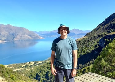
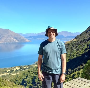
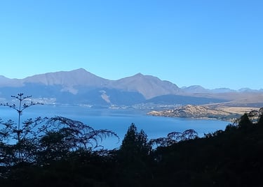
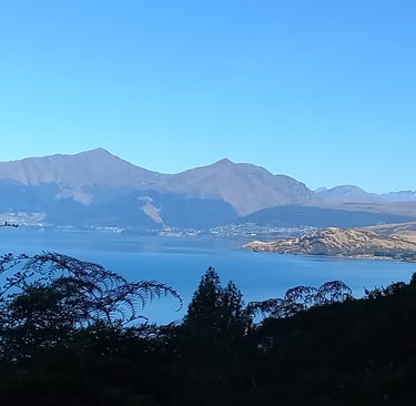
The track is all uphill but the hike to the helipad is a fairly short one - 45 minutes to an hour. The first 20 minutes or so takes you up a number of switchbacks on a 4WD track. It doesn’t take long at all to ascend enough for some gorgeous views over New Zealand’s longest lake, Lake Wakatipu, with rugged Cecil Peak on the far side of the lake and Queenstown in the distance.
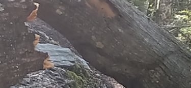
Just as you hit the bushline and just as I was thinking Dang, I didn’t bring any toilet paper, there is a longdrop toilet that has been installed by the local climber’s club with funding support from a couple of local grants and the Department of Conversation (so it tells me on the door). I made quick use of this (just number ones) before being on my way. There wasn’t any toilet paper to take with me, unfortunately.
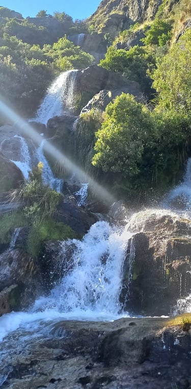
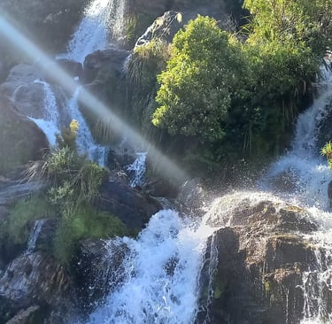
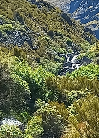
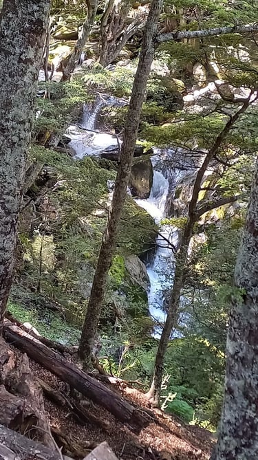
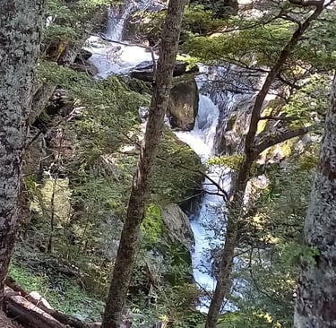
On the way up through what I believe is a pittosporum forest, there are stunning vantage points of the south branch of the Wye Creek leaping from bluff to bluff down the hillside like a powerful beast. Don’t be fooled by the descriptor ‘creek’; both this side and the main branch I will follow a little later are thundering rivers.
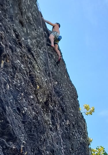
Around this stage, you will come across your first cliff face full of climber’s bolts – I looked up the fancy word for this only to find that it is ‘bolts’ . If you’re lucky, you will see some climbers. I had to wait until my way back for that pleasure.
I’ve always thought rock climbing (and therefore rock climbers) was nuts. Why the hell would you want to put so many metres between you and the ground by scaling soaring cliff faces? Cliff faces that when you make a mistake are hard, craggy, unforgiving. My arms and shoulders would not just sweat but actually cry tears were they subjected to that abuse. My legs would whimper and shake like a beaten dog.
But then I had a sort of epiphany as I walked along. Begrudgingly, respect took hold in my thinking. They are surely a different breed of human beings, rock climbers. Some kind of more evolved species. Like people who do Iron Mans or the Iditarod or other shit like that. It’s pretty amazing! How do they even get those bolts in some of those places?! I still, however, cannot think of anything worse than rock climbing.
The pittosporums give way to beech forest as you get a little higher. You will eventually come to the small hydropower dam on the main branch of the river. A sign saying ‘Track’ (or was it ‘Route’?) points to the left. This leads to the Upper Wye Creek valley and a longer walk through to Lake Alta.
Route to the helipad
To take the short day walk and get to the helipad, as most people do, walk across the dam and continue along the funky boardwalk that runs on top of a section of water pipe. You will reach a second dam and an impressive view of the river crashing down the hillside.
Don’t do what I did – carry on up towards the cliffs. As I climbed, I turned around and saw a group of three standing on the helipad, about 15 metres below me and back on the other side of the river. One was doing a Tiktok dance. Was I meant to keep going and loop back over the river? Nah… I went back down and sure enough, I’d missed the small pathway into the platform just before the dam.
Although I didn’t climb to the cliffs this time, there is a lovely bridal falls higher up on the far side of the river. Pathways created by rock climbers mean there is a chance to hike a few hundred metres and get quite close to that beauty. Unrealised on this trip, it’s a reason I’m looking forward to coming back!
The party on the helipad – three generations; grandad, daughter, granddaughter – was super-friendly and we had a good chat, including short (and civil!) comments on Trump’s re-election. Turns out the girl is not old enough for Tiktok yet, but she is saving up the dances for the day she is allowed to start posting. I took some pictures of all of them and they captured this picture for me 🙂
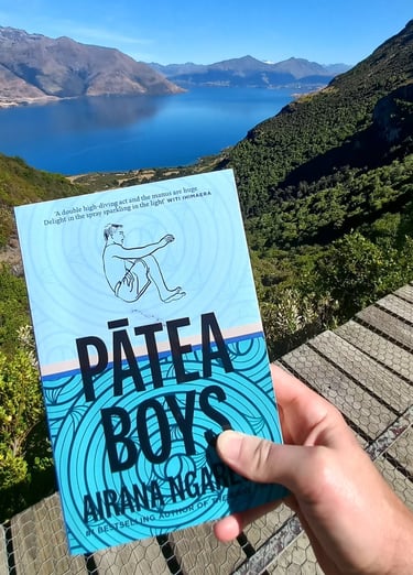
They left and I swanned around on the helipad for a bit. It’s not every day I get to stand (and lie) on a helipad. I gave the book I’m reading right now – Airana Ngarewa’s Pātea Boys – a look at the view because I knew it would enjoy it. What a great collection of short stories about Māori life in rural Taranaki. Unfortunately, I had another trail I wanted to follow and destination I wanted to make. I didn’t have time to read. It was a good headrest for a few minutes sunbathing and shuteye though.
The Rest of the Lower Wye Creek track
Returning to the first power station, I started making my way on the labelled track. This is the track that DOC are talking about on their webpage for the Lower Wye Creek track. Why they don’t mention any information about the pathway over the dam and to the helipad, I do not know. I suggest reading a couple of different blogs about the track – wait, that’s what you’re already doing 🙂
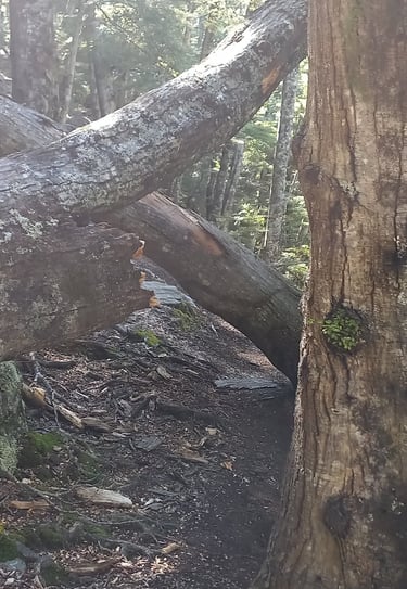
The track is a steady climb through beech forest. Thundering along, the river is relatively close at times but obscured for large parts otherwise. There are quite a few trees down on the track which means a number of alternative routes have been trampled by hikers. Once or twice I had to backtrack a bit and ensure I was on the correct track. Keep an eye out for the orange markers throughout this section – they are fairly regular.
Random socioeconomic aside
(if you’re not here for this, skip to the next heading)
It was around this time I started pondering the widening gap between the super rich and the rest of us, and the problem of limited public funds. Our collective wealth seems to be growing poorer while a select few are creaming it.
I kinda get that wealthy people don’t want to be taxed more if they don’t believe the government is going to use the money effectively. But at the same time, we have to do something. The vast accumulation of wealth in the hands of a few while our health, justice, and education systems creak and buckle (metaphorically, as our infrastructure does literally) just isn’t right. Yeah, it definitely ain’t all roses here in New Zealand, folks.
So how about this? What if very wealthy individuals – I’m sorry, philanthropists – and big companies were mandated by law to set aside a certain amount of profit? Made $100 million in profit this year (Fortune 500 companies made $2.9 trillion in 2023)? 35% of it (let’s say) needs to go into a fund. You decide where it goes. That gets around the government misusing your money. Think using it for increasing the Health Ministry’s wage budget is the most effective spend? Cool. Wanna use it to increase the pot for school rebuilds and upgrades? Awesome. No, you don’t get to put your name on the building. None of that marketing shit. Just some human decency shit.
I know these people and these companies donate large amounts of money. I’m not totally naive to what the wealthy do for society already. But it’s not enough. The wealth of the world’s billionaires doubled over the past decade. There is far too much focus on using wealth to generate more wealth, rather than using it to make a difference for the world we live in and the people who live in it.
Back on track
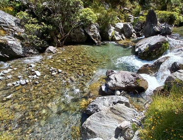
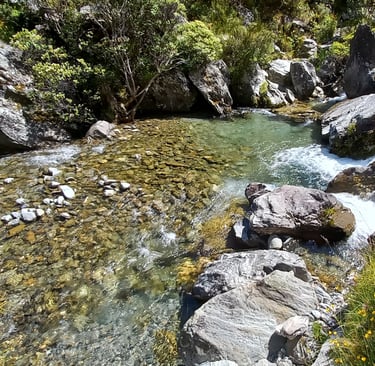
I knew that 11:35am was roughly my ‘halfway time’ in terms of my wife coming to pick up. I was determined to make it through the bushline though. 11:35am came and went, but my body was well warmed up by this stage and I cut a fairly quick track up the ascending path. I felt so good powering through the bush soaked in sweat. By 11:50 am, I popped out into a magnificent alpine valley environment. I had been glimpsing these golden coloured hillsides on the other side of the river through the forest and I was stoked to have made it to them in time.
Almost straight away there is a shallow area where you can cross the creek. I looked around but struggled to see which side you are meant to continue up here – there were no visible orange arrows. The path did appear to continue on the true right but looked quite overgrown, whereas on the true left were wide open spaces to continue up the valley. ChurNewZealand says continue on the true right until you get to a point where you must cross further downstream, so that’s what I’ll be doing the next time I’m up there.
Because even if I don’t want to go all the way through to Lake Alta, there is an insane looking double waterfall – two halves falling symmetrically into each other – a distance down the valley. Another reason for me to come back!
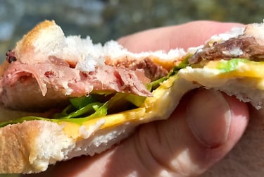
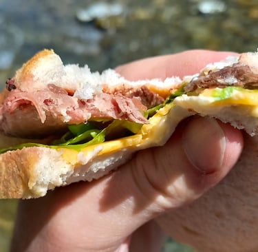
I stopped and took a dip here. It wasn’t the hottest day but it was sunny. The water was bloody freezing so a couple of good dunks were enough for me. Lunch consisted of a banana, muesli bar and a mean steak sandwich (mean (adj.) New Zealand slang for ‘awesome’).
Descent
It was now 12:25 pm. But I wasn’t worried. I had mucked around on the way up, taking lots of photos, overshooting and then lazing around on the helipad, etc. I was fairly confident that keeping a steady pace, I would get down by 2 pm.
On the way back down, I noticed a couple of waterfalls through the bushes which I hadn’t seen on the way up. At least one appeared to have its own side path down the hillside to get a closer look. Not that I had time for that. Another reason to come back!
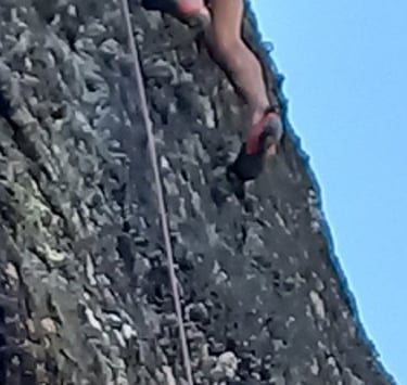
When I got down as low as the first cliffside, I was greeted by a couple of rock climbers; a woman feeding the rope for a man about 20 metres above us. I asked if I could take their picture and they obliged. I stuck around, staring skyward for a while, questions percolating, but they seemed intensely focused (and well, he was 20 metres up), so I didn’t want to bother them too much.
A little further down the track, I turned around to look back to the river cascading down the mountainside. Here was a great shot of the rock climber in profile high up above the ground - awesome! (Freak!)
The 4WD track easily negotiated, I arrived back at the very bottom of the carpark at 1:51 pm. I said hello to a group that was just setting off and gave track advice to a young couple after they locked up their rental motorhome.
Shortly after 2 pm, my wife arrived, one child asleep in the back, the other delighting in telling me about the stress of Mum’s missing phone that morning. My wife kept the adventure going on the drive back into town. The petrol light came on just as we left Queenstown. I’m afraid we’re going to run out of petrol, she told me. I’ll drive, I told her, assuring her we would make it back fine. However, I wasn’t really that sure! Thankfully, we made it.
Summary
Wye Creek track is somewhat strenuous but it’s short. 45 minutes to one hour and you have incredible Lake Wakatipu/Queenstown views in front of you, souring cliffs above you, mighty waterfalls behind you… and a helipad to laze around on.
The main DOC hiking track after that ups the degree of ascent a bit more and has quite a few fallen trees on the track. Keep an eye on the red markers to ensure you’re on track. In a little over an hour, you come out in a lovely yellow-green alpine valley, cutting through by the burbling Wye Creek, perfect for a quick dip on a hot day.